This is partially a reply to both the Niole Dra/Gradsul thread, and the Campaign Preferences thread where GreyhawkGrognard caught my attention with his impression of Nyrond feeling too safe and civilized. This reply is much longer than I intended, so perhaps it's best to post as an article.... but the article queue made it sound like it'll be weeks before it shows up? Dunno.
One problem I have with most maps is they don't communicate scale well. Without proper scale, it's difficult to find creases to place wild areas; as GHGrognard suggests, things become too safe and civilized.
To shake things up, we must re-calibrate our sense of scale (not just geographical, but political or power scales). If we do it right, this allows for many, many more dubious borderlands and opportunity for adventure across ancient and wild lands.
Let me try this with the Niole Dra/Gradsul area: Our venerable Pluffet records Keoland's population as 300,000. The Kingdom covers approximately 130 green hexes. If we evenly distribute these folk across the map, that's only 3 people per square mile! At that rate, how many square miles must be emptied to account for a lowly hamlet of 100?
According to "Medieval Demographics Made Easy," developed land could support a population density of over 120 per square mile. To put this in perspective, the Darlene map shows 4 towns/cities in Keoland. If each of those hexes represent well developed "medieval" areas, those 4 hexes contain 314,000 people -- the remaining 120 hexes in Keoland would have no human population to speak of....
It's clear, then, that Keoland's size and population dictate areas of habitation remain quite small. They coalesce around places of value, and lines of trade. The density of population quickly falls off as you move away.
How could we scale the spheres of power and influence across such a landscape? My approach is that a center of population represents a center of political power. These centers of population, down to the lowest levels, are built on layers of localized, semi-autonomous entities of control, whether a village council, a tribal leader, a petty noble, what-have-you, all building up through higher nobles or higher powers.
Larger dominions, then, are built by tieing these lands together through allegiance... don't forget the degree of command and loyalty may vary greatly, and be in constant contention with other nearby dominions. Hopefully, this emphasizes how a ruler's control relies on fealties, potentially across geographically fractured landscapes. So, even in a "civilized" Kingdom, many, many hexes become uncontrolled borderlands.
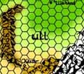
To turn this thought-exercise into something visual, I took one of Anna Meyer's **fantastic** maps of Keoland. I shaded the human-settled areas, arbitrarily based on geographical features and whim, in red.
I scribbled black lines to suggest how power and influence is projected over the inhabited areas. Again, "power and influence" could be various lesser nobles, familial associations, tribal identities, hostage exchanges, guild systems, ancient vows, traditional rivalries (if not traditional enemies), etc. I feel more tension arises if the power-projections form concentric and overlapping circles of various intensity. These become the ~true~ political boundaries... areas beyond these spheres of influence are beyond effective control: there's no one to govern, no one to be governed; and depending on a DM's imagination, these uncontrolled lands may be unknown, undesirable, untenable, unmanageable, and downright dangerous. Sorry, we don't know what's over that next hill. Those brave or foolhardy enough to look never come back.
One result of limited lines of power is the dotted line boundaries for earldoms, duchies, counties, and kingdoms could or should be left undrawn. They ~are~ useful as an input to riff ideas from, though, but don't let them dictate. An example of what I mean: I placed an inhabited area which turned out to be right on the boundary depicted between the Earldom of Gand and the Duchy of Gradsul. Since ~my~ boundaries of influence don't match up with someone else's rendition, we could use this conflicting depiction to suggest ideas:
1. Neither the Earl nor Duke nor King hold sway in this area.
2. The Duke or Earl covet the allegiance of this area to extend their influence.
3. The ruler of this in-between area switches allegiance to whoever gives the best gifts.
4. The Duke and/or Earl will petition the King to put the unruly nobility of this in-between area back in their "place."
5. The inhabitants are a migratory tribe
The list can go on and on as imagination permits. None of these need be the focus of any gameplay (unless that's the players' style); I intend it as a thought exercise to challenge the idea that any ruler's influence and power, overkings included, stretch consistently from solidified border to solidified border. Borders are not created by lines on a map, they are created by who is aligned with who, and how far their power and influence stretch. Power reduces the farther away you are from their power-base, so things get gray and foggy at the edges. And once we re-add uncertainty back into the map, it reveals many more unsafe, uncivilized places spread liberally within the borders of a seemingly stable land.
A King is just another sphere of influence, and he may not be the only "King" present in the land. For example, the Duke of Gradsul ... he may be a King of the ancient inhabitants of the mouth of the Sheldomar. Gradsul is only part of Keoland because a nominal allegiance exists. If the connection between the Duke and King is not very strong, then depicting the land as a Heat Map concerning the Keoish king's influence, Gradsul is a very cool area. And, if the Duke of Gradsul has a lot of influence over the Baron of Riverwatch due to ancient affiliations predating the creation of the Keoish monarchy.... whichever way the Duke goes, the Baron goes. How is Niole Dra going to fair if it loses the Sheldomar river way?
One thing I notice going through this kind of exercise: the placement of many towns and political boundaries on maps (whether it's the original GH map, or later additions like Living GH) often strike me as non-sensical... but that unpredictability is a fun way to spark new ideas. For example, why the ~heck~ would a town exist deep in the Dreadwood? Zero safety, and extremely poor lines of trade/communication with the outside world. Explaining these oddly-placed locations hopefully spawn great and fantastic ideas.
In the same vein, oddly placed political boundaries (such as splitting an area of high value), entice interesting tensions and imbalances, just ripe for explosion.
On top of all this... consider Fey Lines. Persistent lines of magic power might explain the locations of features like the Elsberedeth Druid Grove, and why there's no real inhabited areas surrounding for 50 miles... If some of these lines run through uninhabited border areas... crossing that kind of ground is a bad recipe for altered realities. Is the triangle formation of Niole Dra, Tringlee and Jurnre with the Silverwood at the base, just a coincidence?
I also like to think of Fey lines similar to weather patterns. Fluid, shifting streams of energy transmuting the magic weather systems like a change in the Jet Stream. "Today, a High Pressure Chaos Magic front will move through bringing ill luck and failed spells for Lawful wizards. Expect better Magic Weather later this week when a low pressure Good Zone coming up from the southeast takes over. A Faerie Fog Warning is in effect for the Lowlands tomorrow morning; keep your children indoors, and as always, don't forget to dress appropriately: young boys should be clothed as girls to reduce chance of Faerie abduction...!"
A change in the weather can mean the difference between a forest path leading to an expected destination, or to something that didn't exist there the day before.
My whole point is there just isn't enough people in Greyhawk to maintain consistent control across all the green hexes. The numbers and distances dictate that centers of population and control are not created nor distributed equally: they often lie fractured across each kingdom, or principality, or prelacy, or whatever country exists on the GH map. Allegiances exist in varying degrees of loyalty, therefore, borders are fluid and fuzzy even within an ostensibly well-defined land. Plenty of unsafe, uncivilized areas wait to be filled with whatever fantasy elements drive your campaigns. Instead of travelling a thousand miles to find an adventure, the world can be scaled properly to make it feasible to travel 10 miles. Those 10 just need the right backdrop of uncertainty and danger to keep 99.9% of the folk from going beyond what they see from their village outfields or even castle walls.
I agree with your observation that the depiction of political borders creates a false sense of a political entity's exclusive power or dominance in that region. (Its wonderful that Anna Meyer's maps allow you to turn those on and off.) Your visualization of the "settled" regions helps. I have also tended to designate "cultivated" areas when detailing an area on my own maps (ugly scribble that they are).
Looking at the Flanaess as you have, does it indicate to you that there could be whole additional political entities which the human-centric Gazetteer just ignored? It does to me, especially where it consists of other races who don't share the political structures of which the Flanaess humans are familiar.
What does this say about the population numbers in various sources? How much population has been excluded? What population was counted? This becomes even more troublesome when you think that "cultivation" or "settlement" may look a lot like wilderness when performed by some creatures (treants using the "herders of trees" motif as one example).
I've always wondered what a Gazetteer of the Flanaess would say, if it was written by the more intelligent giant races, or by dragons, or the intelligent undead, or anyone but humans.
Perhaps the most significant game effect is that whole new settlements, cities, tribes, populations, etc., can be discovered by the players, and it won't seem particularly ridiculous. Or the party can journey extensively and never come across another settlement. Either way.
I think it really pays off to consider the things you have discussed to give a campaign world a feeling of life. In particular getting a grasp of population density is something worth looking into.
As A-Baneful-Backfire mentioned, I think it's definitely worth considering non-human groups into the mix. Also, I've always been intrigued by references of tribesfolk in the World of Greyhawk regional encounter tables. I've always assumed many of these are remnants of Flan tribes now living in more remote or inhospitable areas but still a presence nonetheless.
This reply is much longer than I intended, so perhaps it's best to post as an article.... but the article queue made it sound like it'll be weeks before it shows up? Dunno.
Tsk! And here I had moved your article to the front of the line for variety's sake.
I once thought that regions of 'civilization' were without peril and wilderness adventure...until recently. My player has some characters in the Domain of Greyhawk, and as I lean more towards outdoors campaigns, I almost glossed over all the great adventure hooks and ideas spawned for the surrounding areas. However, we had a very rigorous, challenging, and successful run in the Cairn Hills for many, many sessions. This led to another adventure hook in the plains region, soon followed by a trek to the Mistmarsh.
If all that be be accomplished in just a small region surrounding a metropolis like Greyhawk City, imagine what you can create in other 'civilized' regions. Of course, it merely takes the willpower and creativity, as well as some good maps and sourceguides, to pull it off. But that's part of the fun, is it not?!
Tsk! And here I had moved your article to the front of the line for variety's sake.
Sorry, Mortellan, the internet spoiled me with instant gratification!! My lack of faith perhaps make me unworthy to jump the queue!
Back of the line! :)
A-Baneful-Backfire wrote:
does it indicate to you that there could be whole additional political entities which the human-centric Gazetteer just ignored? It does to me, especially where it consists of other races who don't share the political structures of which the Flanaess humans are familiar.
Great idea! I think playing with various layers can lead to unexpected creativity. If reconciling "random" patterns produces new lines of thought... awesome. It's then ~useful~ if players can interact with the result.
Wolfling wrote:
I've always assumed many of these are remnants of Flan tribes now living in more remote or inhospitable areas
That's another great example of another "layer." They could be Flan, or even pre-Flan if ~that~ kinda thing is appealing. Cultures, languages, tribal magic, and religions pushed to less-accessible areas.
Lanthorn wrote:
I once thought that regions of 'civilization' were without peril and wilderness adventure ... successful run in the Cairn Hills
Regarding "wilderness" adventure. Keep in mind the scale of the maps. There ~are~ large forests which remain unmapped. One of the reason for my "Fey Lines" is crossing through them threatens to open doors to otherworlds. Think of Doctor Who's Tartis. It defies space when you go inside. So a 20 mile stretch of trees which lie along a persistent Fey Line can have endless possibilities when you go in (and some character types may be more sensitive to these lines). And/or things on a map dont need to exist there ~every~ day... a path leading to a stately manor... doesn't need to be there the next day if the manor is a manifestation from another plane of existence.
I'm sure folks beyond just myself might be interested in some of the "stuff" that made your Cairn Hills campaign successful and sustainable in a modest amount of area.
Ek, Interesting and thought provoking..
I too enjoyed your choice to use Anna's maps as a reference point. And your link to the Random Kingdom Population is a tool I will put to happy scrutiny and use.
I would for sake of the "dark-side" critique.. add the following....
ek wrote:
One problem I have with most maps is they don't communicate scale well. Without proper scale, it's difficult to find creases to place wild areas; as GHGrognard suggests, things become too safe and civilized.
To shake things up, we must re-calibrate our sense of scale (not just geographical, but political or power scales). If we do it right, this allows for many, many more dubious borderlands and opportunity for adventure across ancient and wild lands.
You are spot on to say the scale of things should be considered, however, we collectively would have to agree that whether we chose to enlist the Darlene, Anna, or Grognard, (as well as others) maps into consideration, all were en-fact well "scaled" as geographical, not population density, nor resource driven maps.... There were (and it eludes me at the moment) rudimentary maps that did make some attempt as to resources and population densities. It is unfair to critique their maps for "scale" when the common form of measure is "apples vs oranges".
ek wrote:
Let me try this with the Niole Dra/Gradsul area: Our venerable Pluffet records Keoland's population as 300,000. The Kingdom covers approximately 130 green hexes. If we evenly distribute these folk across the map, that's only 3 people per square mile! At that rate, how many square miles must be emptied to account for a lowly hamlet of 100?
As discussed in other threads on CF while the PFS populations appear low, they make no ready accountancy for demi-human nor humanoid populations and their effects on those populations. IMC Fey and Celeni Elves pay little heed to human lines on a paper (borders) as in their words " The humans make war over a thing that does not exist and continually changes with the passage of time." To put plainly they cannot walk to a spot on the ground in the Welkwood or the Gnarley and say here forth is Furyondy or Ulk. They define borders by tangible boundaries, in this case the Jewel and Velverdyva rivers. To your credit you do bring this to point further in your passage.
But even they sway with the passing of time.
ek wrote:
If each of those hexes represent well developed "medieval" areas, those 4 hexes contain 314,000 people -- the remaining 120 hexes in Keoland would have no human population to speak of....
Key word here is Human
ek wrote:
Larger dominions, then, are built by tieing these lands together through allegiance... don't forget the degree of command and loyalty may vary greatly, and be in constant contention with other nearby dominions. Hopefully, this emphasizes how a ruler's control relies on fealties, potentially across geographically fractured landscapes.
............
I scribbled black lines to suggest how power and influence is projected over the inhabited areas.
Coming from a region of the country that is, shall we say, known for vastness (TEXAS) Historically, "power & influence" were not defined solely by population density. There were (and are) many vast ranches that were established and controlled with minimal populations. I would even further the Apache Nation and the Khan dynasties controlled vast regions with out the definition of "settled" areas.
ek wrote:
Borders are not created by lines on a map, they are created by who is aligned with who, and how far their power and influence stretch. Power reduces the farther away you are from their power-base, so things get gray and foggy at the edges. And once we re-add uncertainty back into the map, it reveals many more unsafe, uncivilized places spread liberally within the borders of a seemingly stable land.
Yep, Well Put.
ek wrote:
I also like to think of Fey lines similar to weather patterns. Fluid, shifting streams of energy transmuting the magic weather systems like a change in the Jet Stream. "Today, a High Pressure Chaos Magic front will move through bringing ill luck and failed spells for Lawful wizards. Expect better Magic Weather later this week when a low pressure Good Zone coming up from the southeast takes over. A Faerie Fog Warning is in effect for the Lowlands tomorrow morning; keep your children indoors, and as always, don't forget to dress appropriately: young boys should be clothed as girls to reduce chance of Faerie abduction...!"
Love the analogy, and my sentiment exactly.. this is one of t he elder groups of races that should view humans as "greedy children" that have come into their lands and claimed that which is not theirs.
ek wrote:
My whole point is there just isn't enough people in Greyhawk to maintain consistent control across all the green hexes.
People perhaps, but "people" aren't the only ones in control.
Good Article, will love to see where this goes.. maybe a population density overlay on Anna's or Darlene's map?
Ek, I love your topic. Your views on this are *great*.
For my part, I have been working for quite a time on a project to compare maps of GH with real-world countries. It is clear that the areas depicted on the Darlene map are huge and under-settled - with humans. (As an example, Keoland and the Sheldomar are almost as big as Mexico, short of Yucatan. By the way, they also lie at the same latitude.)
The under-settled state (by _Human_ population, thanks Black Lord) of the Flanaess is of course consistent with the D&D game, where big "empty" areas are needed to leave room for monsters and adventure. But I love the way you demonstrate that there is actually room for more than "monster land" : there could also be small "countries" or "states" of sentient species of whom the Human rulers nearby are almost unaware (or these rulers don't care, but then this could prove a mistake, for various reasons...) By the way, these sentient species do not have to be all-compulsively aggressive towards humans or demi-humans. Lot of interesting "societies" are likely waiting to be describeb, and maybe there lies a much more diverse world than we thought. Well, at least that's the way I see the Flanaess.
Especially, around the Keoland area, I envision the whole Javan valley as such a place peopled by "other" sentient races. The Javan river flows through naturally remote regions, especially the part between the Good hills and the Jottens / Little hills. But most of its course goes through regions unhospitable to humans. Thus, place for others. :-)
Love also the idea of Wolfing to see "tribefolks" as remnants of the Flan or others ! Hey, the Flanaess get's peopled, at last ! :-)
Thanks for this thread, Ek. Great inspiration. And beautiful map. (Btw, how did you draw the rendition of the human settlements ?)
Another take on the figures provded by the Savant Sage is that they are under-reported. Page 19 of the Living Greyhawk Gazetteer states that "Previously published population figures for the Flanaess were often very low given poor census-taking methods and outright falsification." For instance, Nyrond goes from 1,375k in the original set (576 CY), a post war low of 1,175k in From the Ashes (585 CY) to 2,618k in the Living Greyhawk Gazetteer (590 CY). Now, unless everyone got really, um, busy, in those five years, it is unlikely to be due to births. Since none of these areas are trying to get seats in the House, but minimize the provincial tax load, this makes a lot of sense.
Another great idea! Especially because I mis-typed: I meant to say *Ley* Lines!
One thing I had in mind for this is a multi-layered transparent overlay, each layer composed of translucent cloudy patterns. Shifting or rotating over time makes an ever-changing pattern of densities over a given area of land (think weather.com animated maps, but with multiple agents and different swirls of directions). The denser the color, the more pronounced The Effect. It could be luck, magic potency or any effect you wish. It might control the ether "winds" which enchanted airships navigate... whatever creates a compelling environment for your players.
Dark_Lord_Galen wrote:
all were en-fact well "scaled" as geographical, not population density, nor resource driven maps....
Lack of clarity on my part. I don't intend criticism of the popluation numbers, but to impress the fantastic flexibility they afford us. As soon as we feel like no un-trod, un-settled, un-controlled land remains, we may have overestimated the population and underestimated the size of the Flanaess. A subtle change of perspective ("scale") may allow *more* adventure concepts into a smaller area. Danger is not a thousand miles away: it is just beyond those oddly swaying trees....
What else I mean about scale of the map: the size of the land dictates there are many more rivers than drawn, many more hills and crags than shown, many more forests and lakes and swamps than admitted. Don't be fooled by an "empty" green hex... it's really a carte blanche for whatever twisted, angry, lovely, woeful, heroic concept you want.
Dark_Lord_Galen wrote:
maybe a population density overlay on Anna's or Darlene's map?
If the idea sounds useful, then I encourage different DMs to generate their own to see what nooks and crannies they exposes in *their* version of Oerth. ~That's~ what I like: seeing Greyhawk become a melting pot of ideas, molded and melded, no two worlds the same, but each a source of creativity fueling and propelling fresh ideas for everyone to use, abuse, or discard as they like.
Dark_Lord_Galen wrote:
(TEXAS) Historically, "power & influence" were not defined solely by population density. There were (and are) many vast ranches that were established and controlled with minimal populations.
Sure! This idea could be put into service on various levels. Maybe certain non-human denizens have this type of structure. It might even be feasible for humans in some areas. However, depending how dangerous we envision our world, having low numbers attempt to ~control~ large areas of land leads to quick and nasty disappearance of said folk. Foolish humans.
Sword_of_Skule wrote:
And beautiful map. (Btw, how did you draw the rendition of the human settlements ?)
The beauty you see is Anna's work, not mine. I just used the Airbrush tool in GIMP and sprayed red. Then I scribbled circles/ovals with the pencil tool, suggesting overlapping or varying strengths of claims and concerns (you could see "what happens" if you do this for different guilds, schools of magic, local religions). They don't need to be thought out... do whatever starts writing stories in your head. My intention was to break up the concrete of a Kingdom, so, I focused on localizing the power structures. The Kingdom still exists, but it's clearly a patchwork of separate allegiances over non-contiguous settlements; vast areas still remain outside human control.
Just by considering population densities, we've provided lots more wildlands for the imagination.
I also like to think of Fey lines similar to weather patterns. Fluid, shifting streams of energy transmuting the magic weather systems like a change in the Jet Stream. "Today, a High Pressure Chaos Magic front will move through bringing ill luck and failed spells for Lawful wizards. Expect better Magic Weather later this week when a low pressure Good Zone coming up from the southeast takes over. A Faerie Fog Warning is in effect for the Lowlands tomorrow morning; keep your children indoors, and as always, don't forget to dress appropriately: young boys should be clothed as girls to reduce chance of Faerie abduction...!"
A change in the weather can mean the difference between a forest path leading to an expected destination, or to something that didn't exist there the day before.
Dark_Lord_Galen wrote:
Love the analogy, and my sentiment exactly.. this is one of the elder groups of races that should view humans as "greedy children" that have come into their lands and claimed that which is not theirs.
Another great idea! Especially because I mis-typed: I meant to say *Ley* Lines!
One thing I had in mind for this is a multi-layered transparent overlay, each layer composed of translucent cloudy patterns. Shifting or rotating over time makes an ever-changing pattern of densities over a given area of land (think weather.com animated maps, but with multiple agents and different swirls of directions). The denser the color, the more pronounced The Effect. It could be luck, magic potency or any effect you wish. It might control the ether "winds" which enchanted airships navigate... whatever creates a compelling environment for your players.
I know it's only peripherally related to the majority of this thread, but, I figured that since it's discussed in the OP (and a cpair of posts thereafter) I would go ahead and put it here.
I really like the idea of "Ley Lines" that are similar to things like the Jet Stream in our own world. I have thought of scads of variations on it, but the first place that I ever saw the idea was in Robert Lynn Aspirin's Myth Adventures series with Aahz and Skeeve. In it, magic is contained in leylines, like you're describing (but, I don't remember what the books call them)... although, often on a much more localized scale, and not as entirely "mobile" as weather is, and leylines aren't as big as entire weather patterns. In the novels (I don't know if you've read them), they vary in size. They can be massive things like an invisible river floating through the air, or they can ba a tiny thing (theoretically) as small as a thread. But, I *really* kind of like the idea of ley lines flowing and moving on a daily and seasonal basis. Interestingly, in the novels the magicians have to use something akin to Detect Magic to know what kind of magic is about. If a Magic-user believes there to be little or no magic in a particular place or plane, it can catch him by surprise if he doesn't know that there happens to be a single large leyline nearby. Although that would technically run counter to D&D rules in that (according to 3rd Edition sourcebooks) a magic-user immediately knows when they've been cutt off from magic.
I can't seem to recall whether I took my own idea of different (coloured) lines for different schools of magic, or if that's something that's in the novels as well. I did a bit of reading today about the origins of leylines, and how they're represented in contemporary fiction. It's shocking how many places this concept can be found. (a good list is easily found here at TV Tropes.)
Of note a little more directly related to GH - does anyone know if a description or disertation on the precise nature of magic on Oerth has been given? Even in a source like the Oerth Journal, or anything?
EK, if you'd like to, we can branch the discussion off into a seperate thread discussing magic in this form ... and whether we discuss it in relation to GH, or just talk about cool magical stuff doesn't matter to me, at all. It could be in The Heretic's Nest, for all that matters. _________________ Owner and Lead Admin: https://greyhawkonline.com<div>Editor-in-Chief of the Oerth Journal: https://greyhawkonline.com/oerthjournal</div><div>Visit my professional art gallery: https://wkristophnolen.daportfolio.com</div>
Ley lines are mentioned in The Star Cairns. Each of the Star Cairns is built on a different ley line, which gives a penalty to saves against spells of a certain school. Exactly which school changes over the centuries as the focus of the ley line shifts. Sometimes the ley line shifts away from a site entirely.
Ley lines are mentioned in The Star Cairns... (and more *way* cool stuff!)
He Shoots! He SCORES!!! Rasgon for the WIN!!
Man ... canon reference. It certainly makes sense that there'd be some reference to leylines [/i]some[/i]where in Greayhawk. I think that it would be safe to assume that if they exist at the Star Cairns, they exist elsewhere. Surely they're not an isolated magical phenomenon. Where they would be is left entirely up to the GM, but, I garauntee that I will certainly be useing them next time an arcane spellcaster uses Detect Magic when I'm running a game.
On a marginally related note ... "seeing" magic: Can you imagine the aura that must've lingered after the Flight of Fiends? A world-wide aura of epic/deity level magic covering up and blotting out every other aura for a week! Whoosh!
Nice idea! I'll have to incorporate that into the campaign, if I ever run one during that event.
I rather prefer the lower population levels from earlier editions. For my own gazeteer, I decided to meet in the middle. I agree that even 'civilised' lands need not have dense populations. most settlements would be subsistence farmers living close to arable soil and a water source.
Comparisons to medieval populations are somewhat moot. We have deities who are holding back the development of these societies (the gods don't permit smoke powder to work unless under the guidance of Murlynd) and this could include birth rate.
We also have to consider that, unlike the real world, there are dozens of highly intelligent races competing for scarce resources above and below ground quite apart from evil cults creating mischief. Adventurers, wizards, and healing clerics are too scarce to make a massive difference overall.
I think that there would be many areas of 'wilderness' a few miles away from established trade routes and farmland.
The Living Geoff campaign had a fair bit on ley lines and 4e introduces the concept of 'the Ways of the world' as a method of travelling using ley lines bordering the feywild.
I'm not going to try and get involved into the discussion, I just wanted to say that this thread shows the depth and dedication of the Greyhawk community, I love to read this stuff!
I want to thank ek for using my map in his illustration of the topic, love to see my work being used!
Comparisons to medieval populations are somewhat moot. We have deities who are holding back the development of these societies (the gods don't permit smoke powder to work unless under the guidance of Murlynd) and this could include birth rate.
I think specifically, the availability of healing magic, no matter how rare, has retarded most medical research beyond first aid. Semmelweis will have to wait.
OK, I guess I found a thread that actually addresses this issue.
I was looking at the Duchy of Ulekt, as my party is traveling through there now. Anna's beautiful map gives a very nice breakdown of the various counties/duchies/etc. I was considering doing a very quick bit of work to flesh them out some more, add in roads and such, and basically just have a bit more to go on.
As my party was coming via the Silver Path, crossing the Lortmils from Veluna, I was going to start with the County of Carnelis. It seems a rugged frontier county, along the foothills of the Lortmils, centered on what seems a large valley running east/west. With no cities or towns shown, and since the party would go here first, it seemed a good place to start.
I planned on using the Doomsday Book, as noted earlier in this thread.
It's something I've used when creating my own worlds, but never really related it to Greyhawk. I created a quick map using Campaign Cartographer, which has a nice feature whereby you can click around an area to get the square mileage. I did that I and came up with the following square miles for the County of Carnelis: 6000 square miles.
Since the Doomsday Book works with square kilometers, I had to convert. I came up with 15540 square kilometers. Plugging that into the calculator and chose rocky/chilly for terrain (15 people/km). I ended up with the following totals:
Total Population: 225,000 people
Isolated: 4500
Villages: 200250 in 445 villages
Towns: 20250 in 5 towns
Ave distance between villages: 6km
Ave distance between towns: 55km
Now, there are lots of other things, like fowl and such, but this is what I wanted to consider. How out of balance is this? I mean, it's a tremendously huge difference. When the entire Duchy of Ulek has a reported population of about 400,000, so it's obviously a big deal.
For fun I put in the square miles of the entire Duchy. That was about 55,000. Converting that I had 142,500 square kilometers. The result was the following:
Total Population: 2,137,500 people
Isolated: 42750
Villages: 1902375 in 4228 villages
Towns: 128,250 in 26 towns
Cities: 64125 in 6 cities
Ave distance between villages: 6km
Ave distance between towns: 55km
So, we have a huge difference, and I'm just wondering what people think of this. I could just ignore this, cut the numbers by what, 80%, and call it good. Obviously, that's the easy way out. So, I wondered what you all thought.
I would take into account who is living in there. More than half the population of the Duchy of Ulek is made up of elves and half-elves, and as such folks will live in the area for a longer time than other races, their tendencies might rub off on others. Accordingly, the Duchy of Ulek may, overall, have a very agrarian feel to it, and so its populace is not prone to living all bunched up like others are. Even their more populated cities might be spread out and sprawling, with the suburbs being literal rural areas. Also, demi-human populations do not increase at the rate human populations do, which could have the population being closer to 5-7 people/sq. kilometer. The Hateful Wars would have had a huge impact on the populations among demi-human too. _________________ - Moderator/Admin (in some areas)/Member -
That may work for the Duchy, but what about all the other kingdoms? I guess you could just go with the smallest density, to keep numbers small, but that really flies in the face of "reality." Well, for what it's worth. BTW, here's the link to the article Medieval Demographics Made Easy, upon which the Doomsday Book is based:
Anyway, even if you add in the numbers listed for the demihumans, you get only 20,000 more. Quadruple that to get total numbers (i.e. women and children) and you get 60,000 more. That now brings the Duchy of Ulek up to 480,000. It's still only at about 20% of what the calculator says it should be. Also consider, I calculated things at the same populations density that I was using for the County of Carnelis, 15 people/sq. km.
If you look at Europe in the 11-15th centuries, England has the lowest pop density at about 40/sq km. If I use that number I get 5,700,000 people! I guess the calculator is already cutting things about in half, since it only goes up to 45. Consider that France was over 100, so real numbers should even be higher.
...Let me try this with the Niole Dra/Gradsul area: Our venerable Pluffet records Keoland's population as 300,000. The Kingdom covers approximately 130 green hexes. If we evenly distribute these folk across the map, that's only 3 people per square mile! At that rate, how many square miles must be emptied to account for a lowly hamlet of 100?
According to "Medieval Demographics Made Easy," developed land could support a population density of over 120 per square mile. To put this in perspective, the Darlene map shows 4 towns/cities in Keoland. If each of those hexes represent well developed "medieval" areas, those 4 hexes contain 314,000 people -- the remaining 120 hexes in Keoland would have no human population to speak of....
It's clear, then, that Keoland's size and population dictate areas of habitation remain quite small...
...but, using Keoland as an example, the population does increase:
Wolfling wrote:
...As A-Baneful-Backfire mentioned, I think it's definitely worth considering non-human groups into the mix...
...and here:
Wolfling wrote:
...Also, I've always been intrigued by references of tribesfolk in the World of Greyhawk regional encounter tables. I've always assumed many of these are remnants of Flan tribes now living in more remote or inhospitable areas but still a presence nonetheless...
...and here:
tarelton wrote:
Another take on the figures provded by the Savant Sage is that they are under-reported. Page 19 of the Living Greyhawk Gazetteer states that "Previously published population figures for the Flanaess were often very low given poor census-taking methods and outright falsification." ...
...I readily accepted the LGG's assessment on that basis, and because I always thought that the urban to agricultural ratio was way too high in the Flaneass, even when you take magic into effect. So, adding all the sentient humanoids, we end up with something over 1.8 million.
One more point:
ragnar wrote:
...Quadruple that to get total numbers (i.e. women and children) and you get 60,000 more...
The LGG figures are for adults, both male and female. If we have 1.8 million adults, then (including children), you're looking at somewhere between 2.5 million and 4 million.
Using your [ek's] area figures, that would give Keoland a population density of 25-40 per square mile, which is less than the ideal, but (IIRC) was fairly typical of the Late Middle Ages. But that was still quite open, if you figure 5-10 people per dwelling, and if you assume that the overall average is lower due to the number of people in large towns and cities (Gradsul, Niole Dra, Flen, Cryllar), so your basic point holds to some extent.
tarelton wrote:
...I think specifically, the availability of healing magic, no matter how rare, has retarded most medical research beyond first aid. Semmelweis will have to wait.
-Actually, I've always assumed that it would work the other way:
1) In good lands, at least, even serfs might get access to the occasional Cure/Remove Disease spell (castable by any 5th level Cleric).
2) I assume that the Flanaess' understanding of sanitation is actually much better than that of our Middle Ages. For example, people always had an inkling that filthy living conditions had something to do with disease, but couldn't explain what it was until Pasteur (George Washington fought a long battle to clean up Continental Army camps). But in the Flanaess, it's different:
[In the early years of the migration]
Cleric of Delleb, using a Commune spell: "Oh, Guardian and Purveyor of Knowledge. There is a theory that funky living conditions breed disease. What say you?"
Delleb: "Well, duh. Stop taking a dump upstream from where you drink, dumbass."
Cleric of Delleb, using a Commune spell: "Thank You, oh Guardian and Purveyor of Knowledge."
This would improve survival rates, particularly for children.
ragnar wrote:
...If you look at Europe in the 11-15th centuries, England has the lowest pop density at about 40/sq km. If I use that number I get 5,700,000 people! I guess the calculator is already cutting things about in half, since it only goes up to 45. Consider that France was over 100, so real numbers should even be higher.
-40 per square Km would be a little over 100 per square mile (close to ek's figure). I don't have it on me, but in my notes, John Hatcher's Plague, Population and the English Economy 1348-1530, p. 71 has a chart that puts England's population during the Middle Ages at a low of a little under 3 million and a high of maybe 6.3 million (before the Black Death).
That may work for the Duchy, but what about all the other kingdoms? I guess you could just go with the smallest density, to keep numbers small, but that really flies in the face of "reality." Well, for what it's worth. BTW, here's the link to the article Medieval Demographics Made Easy, upon which the Doomsday Book is based:
Anyway, even if you add in the numbers listed for the demihumans, you get only 20,000 more. Quadruple that to get total numbers (i.e. women and children) and you get 60,000 more. That now brings the Duchy of Ulek up to 480,000. It's still only at about 20% of what the calculator says it should be. Also consider, I calculated things at the same populations density that I was using for the County of Carnelis, 15 people/sq. km.
If you look at Europe in the 11-15th centuries, England has the lowest pop density at about 40/sq km. If I use that number I get 5,700,000 people! I guess the calculator is already cutting things about in half, since it only goes up to 45. Consider that France was over 100, so real numbers should even be higher.
"Based on" those numbers should be the rule, because the "reality" of Greyhawk is there are various races who are not just out to kill humans and demi-humans, but who hunt and eat humans/demi-humans. That doesn't even take into account the slew of apex predators in Greyhawk that make Medieval European predators look like house pets. And how could we forget all of the full-on evil cults who seek to sacrifice/murder people, or the undead critters who don't just kill people, but kill then and turn them into more undead. A single low- to mid-level necromancer can wreak havoc. There are all kinds of messed up stuff in the "reality" of Greyhawk that will lead to much lower population levels. _________________ - Moderator/Admin (in some areas)/Member -
..."Based on" those numbers should be the rule, because the "reality" of Greyhawk is there are various races who are not just out to kill humans and demi-humans, but who hunt and eat humans/demi-humans. That doesn't even take into account the slew of apex predators in Greyhawk that make Medieval European predators look like house pets. And how could we forget all of the full-on evil cults who seek to sacrifice/murder people, or the undead critters who don't just kill people, but kill then and turn them into more undead. A single low- to mid-level necromancer can wreak havoc. There are all kinds of messed up stuff in the "reality" of Greyhawk that will lead to much lower population levels.
-I suspect that those aren't in addition to, but rather, take the place of, the actual Medieval condition.
Even if it was on top of other causes of death, the dramatic stuff gets the player's attention, but I doubt that 0.1% of the Flanaess' population dies from those causes. That's more than nothing, but it doesn't keep the population down that much.
That's in addition to the medieval condition. As to population, because of all of the dangers around, I have people bunching up much more, as the areas too far from what passes for civilization are exactly the places that get wiped out by monsters, humanoids, slavers, etc. Perhaps my view of the world is a bit more brutal than others. For every group of "good guy adventurers", there is a group of "bad guy "adventurers", and that latter group doesn't follow many, if any, rules, unlike the former. Think about the body count such groups rack up. Consequently, there is a lot of death among the innocent, and less innocent. And so the population increases at a much slower rate, everywhere, and I like it that way because it provides for a lot more of the unknown. _________________ - Moderator/Admin (in some areas)/Member -
...That's in addition to the medieval condition...
-I figure it's the same. We have (and probably always had) serial killers, so does the Flanaess. It's just that, in the Flanaess, they have the opportunity to align themselves openly with a cause. That was easier to do "back in the day" in our own world, too. In pre-Columbian Mesoamerica, if you wanted to eat people and dance around in their skin, all you had to do was become a priest. Just like in the Flanaess. The supernatural dangers may be tougher in the Flanaess, but so are the protections and ameliorations.
Cebrion wrote:
...For every group of "good guy adventurers", there is a group of "bad guy "adventurers", and that latter group doesn't follow many, if any, rules, unlike the former. Think about the body count such groups rack up...
-That's how I run it, but that's no different than the ancient of medieval period (or our own).
Maybe your view of the Flanaess isn't more brutal than mine. My view of the Middle Ages (or the 20th Century) is more brutal than yours?
Cebrion wrote:
...As to population, because of all of the dangers around, I have people bunching up much more, as the areas too far from what passes for civilization are exactly the places that get wiped out by monsters, humanoids, slavers, etc...
-I agree on that, and that the flanaess is dangerous, it's just how dangerous.
You cannot post new topics in this forum You cannot reply to topics in this forum You cannot edit your posts in this forum You cannot delete your posts in this forum You cannot vote in polls in this forum
Canonfire! is a production of the Thursday Group in assocation with GREYtalk and Canonfire! Enterprises