An exciting and stylish new map of the Furyondian City of Crockport! Set following the Greyhawk Wars whilst still ruled by malevolent Xenvelen. Set your adventures there and explore its ways and alleys!
Map of Crockport
By: Yabusama
Used with Permission. Do not repost without obtaining prior permission from the author.
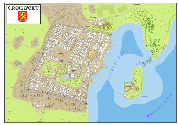
This is a large map of Crockport I created using Adobe Illustrator for my campaign. I have used official sources where possible and just plainly made up other bits. This map is large (84cm x 60cm) but should resize with no problems.
As you can see on the map I have shown Crockport as a walled town, with many siege engines arrayed arounded its southern walls in particluar ( you should be able to make out trebuchets, catapults and ballista), with a trench system for the defenders also present on the southern front aswell.
There are mutliple orcish tribe camps scattered around the lands outside of the city walls, together with the remains of two small villages. All inhabitable buildings are shown in white, whilst those ruined are shown in a sort of smudged outline.
Let me know what you like/dislike about the map. I also have maps of the Vesve region, Dyvers (in progress), Greyhawk City (in progress), Ironstead, Flameflower and Quaalsten. I am happy to post these if anyone wants them.
As I have already said this map is probably not totally canon, so please dont flame me to death lol
Yabusama
Cartographer in the Real World and Greyhawk.
Preview:
Download a larger version HERE
