I always find myself confused by what kingdoms existed when and where and always wished that there were a set of chronological maps showing the development of Oerik.
So, I decided to do some.
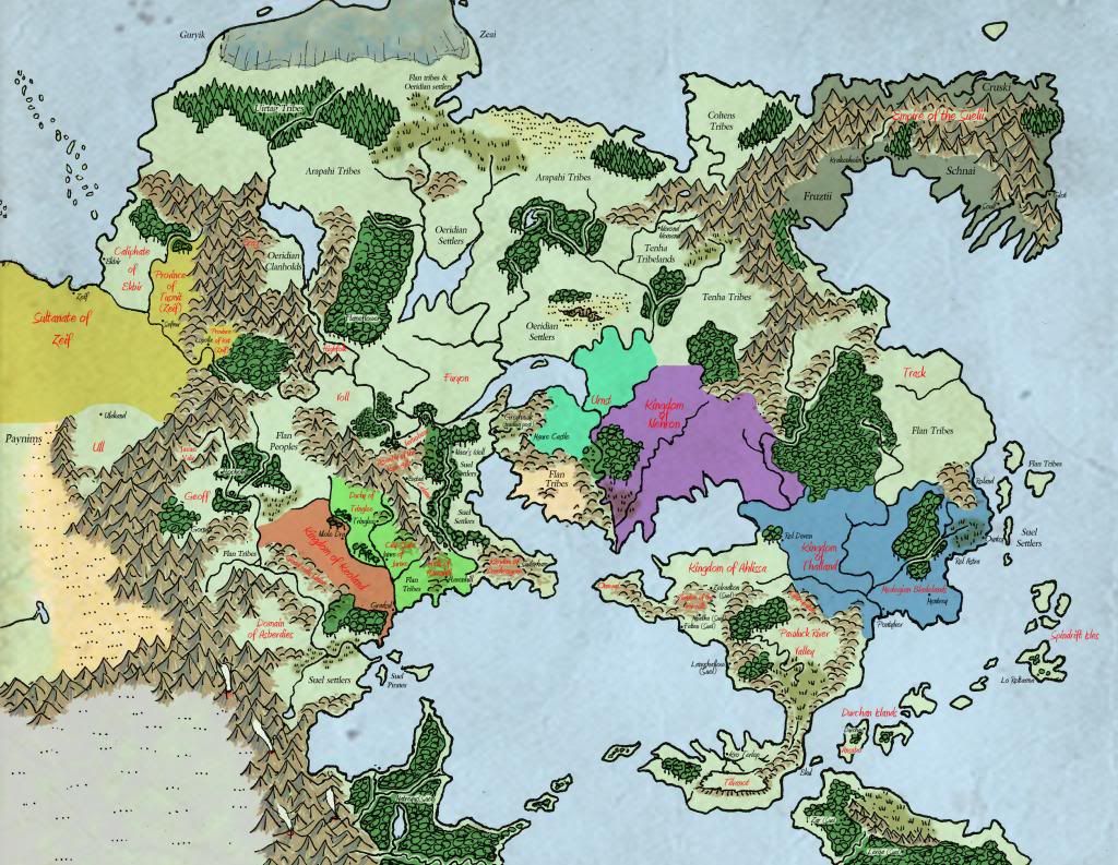
Below is the first attempt set at -300 CY. I plan to do maps from 500CY back through to pre-Cataclysm. There are already plenty of perfect maps for present day thanks to Anna so no need to do any later really.
I'd really appreciate some feedback and thoughts. I'm sure I've gotten loads wrong and I still have some aesthetic tweaks to make but here it is;
That's nice, Wolfling! Somebody did historical maps over time awhile back, using an outline map with just political borders. Can't remember who it was.
The map I see has no national borders - only geographical data. It is a nice-looking map, though. Do you plan to use that as a base upon which to indicate national boundaries for the various ages?
I suggest that you look into the changing geographical data over those centuries, too. For example, I remember reading somewhere that the forests used to cover a vast stretch of the Flanaess - the Vesve, Fellreev, and Phostwood were all part of a single broad forest. Also, magical events have changed the geographical map of the Flanaes - the Isle of Woe were there at one point.
You have to link to the actual image file, not just a webpage with the file embedded in it. Find it by right-clicking and then selecting the option to view the image directly (this will vary depending on what browser you use). You'll know you're there because there will be an image suffix (typically .jpg, .gif, or .png).
Anyway, that's a nice-looking map. I think perhaps we can refine the "Aerdi Principalities" part by noting which cities existed at the time. I can't promise the timeline I'm referencing is 100% accurate, but I think Rel Astra, Pontylver, Ountsy, Roland and Mentrey all existed among the Aerdi principalities then, Rel Deven was the capital of Thalland, and Pontylver was likely the capital of the Medegian Bladelands. In the Kingdom of Ahlissa, Suel of House Zelrad have founded Zelradton, Ingmalt, Minetha, Felten, and Langshallow (later known as Naerie) by -300 CY.
I think the cities labeled above were each the capital of one of the Aerdi principalities at the time.
Warning: speculation.
Rel Deven, capital of Thalland, was ruled by House Cranden.
Pontylver, capital of Medegia, was ruled by House Naelax.
Mentrey was ruled by House Torquann.
Rel Astra was ruled by House Garasteth.
Ountsy was ruled by House Darmen.
Roland was ruled by House Rax.
The Lathu, a Flan people, were conquered by Nehron in -300 CY.
I don't think any other Aerdi cities existed yet; Rauxes (after -109 CY) and Kalstrand (in -250 CY) would both be founded later. So there were six initial principalities, each of them ruling some of the land around their capitals.
A century later Roland would be the home of the Aquaerdians (who would colonize the Sea Barons and Aquaria 70 years after that).
There should be some names of nations on that map SX, mind you they're pretty tiny - I'm trying to make them more visible without being too cramped.
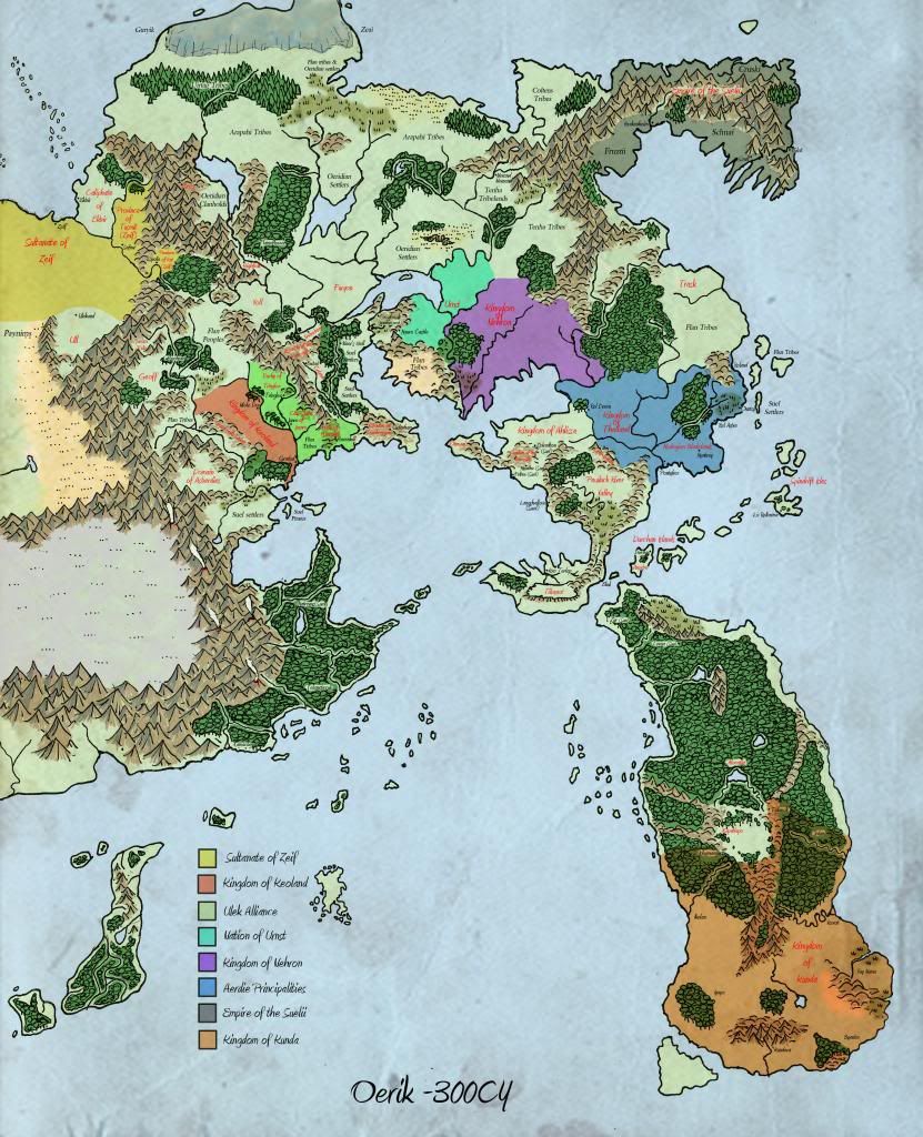
Good point about the changing geographical elements. I've already attempted to enlarge a couple of the forests (notably the Adri which apparently was reduced in size by half since the founding of the Great Kingdom!) I'b be keen to get input on the geographical changes (I'm not expert and I know from previous threads a few of you are!) In particular the changing forest sizes, the changing boundaries of the Land of Black Ice. Would there be much of a change to coastal shape in -300CY?
Thanks Rasgon, I was hoping you'd have some input!
I've added the Aerdie cities on (I'll link to an updated map a bit later).
Would it be worth noting the areas as the "Principality of Darmen" for example or more accurate to just note the locations of the cities down?
Here are some other queries that the map has raised for me;
i) The Suel settlers of the Tilvanot appeared not to have named the area Shar until later on. Did they have a name for their new home on the Tilvanot Peninsula before that?
The Sheldomar Valley brought up a number of questions for me;
ii) The early names of the Ulek states seems unclear to me. The Principality and Duchy were ancient domains of the dwur and olves respectively whilst according tot he Greywiki the County was in -300CY the city-state of Junre. Where does the name Ulek come from. Was it applied to those areas later or was it an existing name?
iii)The Empire of Vecna fell shortly before -300CY. Looking at the map, many of the Sheldomar lands existed alongside his Empire so that doesn't leave much room for Vecna. I guess this isn't relevant on this map at the moment but worth thinking about.
iv) Finally - how about the rest of the map? Have I missed anything significant? I should try and include major settlements or geographical names that might be different (eg the previous name of the Bonewood).
I made a few more changes. I don't think Tenh was quite formalised into a nation yet. Also I wasn't sure if Nehron is classed as one of the Aerdie Principalities or not or where it's capital at that point was.
hmmm the image is tiny too. You might need to save it and then zoom in a bit!
In particular the changing forest sizes, the changing boundaries of the Land of Black Ice. Would there be much of a change to coastal shape in -300CY?
The forests should be much bigger, I think. The coastlines should be about the same. The Land of Black Ice might have been slightly smaller, but I think it had already closed around the City of the Gods.
Quote:
Would it be worth noting the areas as the "Principality of Darmen" for example or more accurate to just note the locations of the cities down?
Keep in mind that my assignment of royal houses to cities is mostly speculative. I don't know for sure that Ountsy was ever ruled by the Darmens or that Roland was ever ruled by the Raxes (both are ruled by House Garasteth in modern times).
Nehron wasn't an Aerdi principality because the Nehron tribe was separate from the Aerdi tribe.
Quote:
i) The Suel settlers of the Tilvanot appeared not to have named the area Shar until later on. Did they have a name for their new home on the Tilvanot Peninsula before that?
The word "Tilvanot" is itself Suel (for "south hill"), so they might initially have called it that. I don't think it was very long before they called their new kingdom Shar, though. Shortly after the coastal towns were founded, I would say. "...two small coastal towns were established to handle trade with other nations. While aloof and somewhat cruel, the new Suel nation - now known by the unassuming name Shar..." (The Scarlet Brotherhood, 3) These towns were probably Kro Terlep and Ekul. I think it's probably okay to call the nation Shar by -300 CY.
Quote:
ii) The early names of the Ulek states seems unclear to me. The Principality and Duchy were ancient domains of the dwur and olves respectively whilst according tot he Greywiki the County was in -300CY the city-state of Junre. Where does the name Ulek come from. Was it applied to those areas later or was it an existing name?
There's a thread on that subject here. I think we mostly all ended up agreeing that Ulek was the name of a dwarven nation in the Lortmils, and the County, Principality, and Duchy were all once vassals of the dwarven ruler. The County of Ulek might have already existed when Jurnre was founded by Immris of Rhola, and it was just absorbed into the county later on.
Quote:
iii)The Empire of Vecna fell shortly before -300CY. Looking at the map, many of the Sheldomar lands existed alongside his Empire so that doesn't leave much room for Vecna. I guess this isn't relevant on this map at the moment but worth thinking about.
Dragon #348 said "As an undying king he ruled a land ranging from the Sheldomar Valley [to] the northwest shores of the Nyr Dyv, although his immediate reach was only the land near his stronghold, called the Rotted Tower in the Rushmoors." Kas's city, Tycheron, was probably near where Dyvers is today. While Vecna's immediate reach wasn't very long, he probably demanded tribute from a much larger area. When the Neheli first founded Niole Dra they were definitely forced to give tribute (or worse) to Vecna, a fact they later tried to cover up by having the Silent Ones and the Knights of the March to seize or destroy any record of Vecna's existence. Vecna's terror probably extended well beyond that.
Note that in -300 CY, Keoland didn't yet include the Dreadwood in its territories.
Your new map's resolution is currently too low for me to read it, even enlarged.
I've enlarged a couple of the forests but I'll do some more on the other next week.
I found a date in the Greychrondex putting the naming of the Tilvanot as Shar a little bit after -300CY.
Thanks for the link about the Ulek States. The only thing that doesn't sit with me about the conclusion is that the Duchy being a vassal state of a Dwarven realm when Celene is next door as well as Olven realms in the Sheldomar. Also the dwarves of Havenhill seemed largely unconcerned with the humans roaming the hills above ground until the early Keoish began offering the hand of trade and friendship. I guess in the absence of canon it might be easier to refer to the Duchy and Principality as North and South Ulek for ease. In the meantime I've put my own placeholder placeholder names in for now.
I'm not sure what's going on with the imag - I'm useless at this sort of thing. Until I find a better site to post the image onto here's a link that should have the map slightly larger!
I note that you have not included the Isle of Dread in your -300 CY map. It was semi-canonized as existing within the WoG in Dungeon #141, Savage Tide: The Sea Wyvern's Wake.
It is located just to the right of your legend, south of the tilted S-shaped island.
Forests won't be noticeably larger. A few hundred years won't see deforestation on the level of full hexes all around the forests being depleted. That would be pretty insane deforestation levels. Go back 1,000 years, and you might then see some hexes worth of trees added to the forest borders. Besides, trees will regrow over a few hundred years, and, more importantly, the Druids of Greyhawk are a little bit more militant about preservation than the tree-huggers of the real world, so the amount of woodland wouldn't likely decrease too drastically in a few hundred years. You might add a little bit extra woodland near larger population centers, as those are the areas where the woodlands will eventually get smaller. _________________ - Moderator/Admin (in some areas)/Member -
On Cebrion's advice I've left a number of the woodlands the same size as either deforestation would not be enough to make a difference or residents of the woodlands mean it has remained relatively untouched. The main forests to be altered are;
The Adri Forest which shrunk by half since the time of the Great Kingdom, The Bramblewood that once grew up onto the foothills of the Yatils but was cleared for farming and the Dapplewood that Furyondy resourced heavilly for timber.
A couple of things I'm unsure of;
i) The size of the Kingdom of Nehron at this stage.
ii) I believe Onnwal became called by that name fairly early on - but as early as -300CY?
iii) Would Voll and Furyon exist at this stage as entities or would it be more accurate to show them as regions roamed by the Vollar and Furyon tribes?
iv) Based on the supposed date the SUelii reached the Rakers and the fact the first Fasstal of all Suelii reigned for only his lifetime before their Empire dissolved, I think that it would be conceivable that it existed in -300CY.
Hopefully this image will be zoomable on, if not I'll try another method (I seem to be having image fail in this thread!)
<sigh> I doubt anyone will be able to read the writing on the map, sorry. I don't know where to upload it to that will keep the resolution integrity. Very frustrating.
I seem to remember that Perrenland was originally peopled by the Flanae, but the migrations map on page 6 of the World of Greyhawk Gazatteer does not indicate that. That is where my mind was picturing that information, but it was faulty.
Is there another source that makes that claim that I am remembering hazily?
You're right SirXaris. It was peopled by some fairly resistant Flan tribes but early Oeridian settlers absorbed the weaker tribes and pushed the more resilient ones into the hills and mountains I think. The lowlands were quickly established as Oeridian clan freeholds. I think Exag remained in the hands of the Flan.
I estimated that due to the proximity of Perrenland to the Fals Gap that by -300CY those Oeridian clanholds would already be present. I should note there being Flan in the hills though.
Forests won't be noticeably larger. A few hundred years won't see deforestation on the level of full hexes all around the forests being depleted. That would be pretty insane deforestation levels. Go back 1,000 years, and you might then see some hexes worth of trees added to the forest borders. Besides, trees will regrow over a few hundred years, and, more importantly, the Druids of Greyhawk are a little bit more militant about preservation than the tree-huggers of the real world, so the amount of woodland wouldn't likely decrease too drastically in a few hundred years. You might add a little bit extra woodland near larger population centers, as those are the areas where the woodlands will eventually get smaller.
I meant to reply to this earlier, but I got lazy. Anyway, I have Ivid the Undying open right now, so I thought I'd throw in this quote:
Carl Sargent in Ivid the Undying wrote:
The Adri Forest is perhaps but half the size it was when the Great Kingdom was founded, but it is still large and shelters many peoples and creatures.
From the first page of the Adri Forest chapter, of course. If that's taken literally, Adri Forest was once a lot larger.
On the other hand, Ivid the Undying also notes that the borders of the Adri Forest are purely political ("(the division of the Adri Forest is
simply one agreed by the landowners around it"). A lot of the land around Adri Forest proper is still probably forested.
I don't think druids are going to be much of a factor during the Aerdi conquest because in that era they're still mostly or entirely Flan, a people who were very definitely on the losing side of the wars for ascendency. Their alliance of convenience with wicked Ur-Flan mages meant they might have had little popular support even among the Flan, but I think if they presented much of a threat to the land-hungry Aerdi then the political map would look very different today. Perhaps they were able to retreat into what is today the Adri Forest, abandoning the wilderness around it.
The other relevant factor, I think, is that while I don't think agriculture was unknown to the pre-Migrations Flan, I think it was practiced on a much smaller scale. Outside of the major civilized Flan realms most of the Flan were thinly-spread nomadic hunters at the time of the Migrations with little incentive to chop down forests, and where they planted crops it was probably in forest glades and the like. The Aerdi, though they were originally nomads themselves, eventually took to agriculture with a vengeance, aggressively clear-cutting vast regions to make way for the massive farms that became the foundation of their economy.
In modern times I think druids are as likely to have Oeridian blood as anything else and they're much more established as part of society and a political force to be reckoned with, with the Old Faith revered in many agricultural communities. I think during the Migrations, though, they didn't have much leverage against the invaders. Stories of Lum the Mad slaughtering Ur-Flan in the Thelwood or the Naelax defeating the sorcerers of the Flanmi River valley were, to a large extent, probably Oeridian battle-mages facing off against druids and winning. As far as numbers, artifacts, and character levels go the Oeridians had an advantage and the druids still had all their eggs in baskets carried by the beleaguered Flan.
Forests won't be noticeably larger. A few hundred years won't see deforestation on the level of full hexes all around the forests being depleted.
This map is interesting:
Source
It shows the loss of primary forests, not deforestation per se, but it's a good example of how fast an empire can chop down trees. No chainsaws or railways required: this was done with eight-foot crosscut saws, teams of horses, and water. States as far west as Wisconsin and Michigan were logged before steam-powered sawmills became popular (link); the Aerdi could do the same thing.
Cebrion wrote:
That would be pretty insane deforestation levels.
According to King of the Dead, Azalin controlled the Ardi Forest from 329-391CY and he was certainly insane!
This is an example of mass colonization and literal reaping of the land for resources by foreign powers though, and that last pic is the aftermath of the industrial era.
Good point though. The Eastern Migrations would set up some deforestation to be sure, but then that goes back before -300 CY (by 200 years or so, depending on what groups you are talking about) which is the target date of this project. After -300 there won't be such massive changes everywhere, as there has already been 200 years of expansive growth. This is medieval tech, and medieval political and secular organization. There are no logging companies for instance, and even water powered mills are going to be rare in most places. Logging on any large scale is going to necessarily be a state-sponsored activity in a feudal society, and there would really have to be a good reason for it Building frontier forts would be a good choice, but that won't clear very much timber on its own. Most state-sponsored building projects are going to revolve around quarrying stone instead. Those who will be using lumber will be commoners making log buildings or beam and wattle and daub buildings. The Great Kingdom would be a good area for some deforestation, as that realm expanded immensely during a 300 year period. Keoland would be another one where the forests could be a bit bigger in the past. Other realms? Not so much, as they are just not expansive/populated enough. _________________ - Moderator/Admin (in some areas)/Member -
You cannot post new topics in this forum You cannot reply to topics in this forum You cannot edit your posts in this forum You cannot delete your posts in this forum You cannot vote in polls in this forum
Canonfire! is a production of the Thursday Group in assocation with GREYtalk and Canonfire! Enterprises


 [/img]