Let's assume for the purposes of this discussion that Oerth rotates and the sun rises in the east and sets in the west just as on earth.
According to the Guide and subsequent sources, prevailing winds in the Flanaess blow from the east (northeast in winter & autumn, east & southeast spring & summer).
Could someone with a better grasp on climatology than me state whether this situation is odd or not? Would we expect, all things being equal, that prevailing winds blow from the west instead as they do across North America?
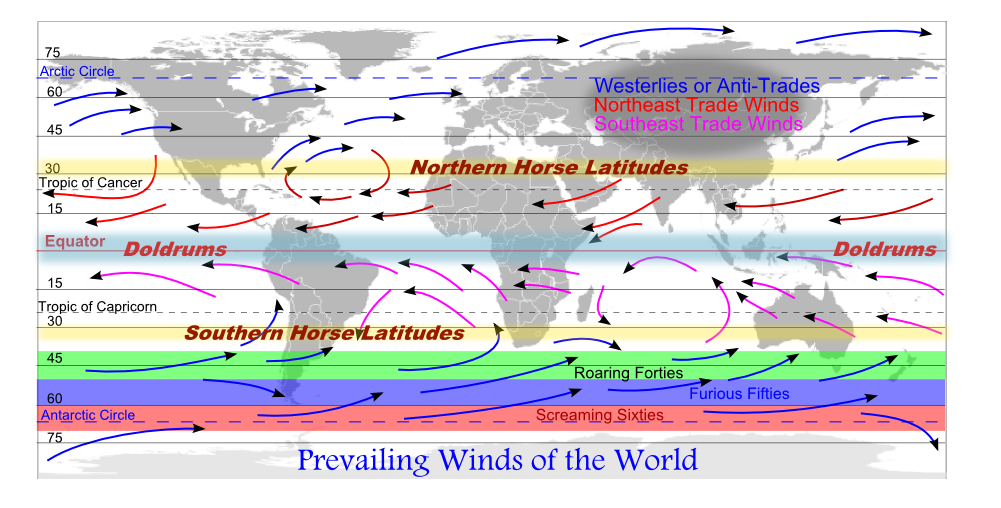
The above image shows how the prevailing winds on earth generally move. As you can see, for the first 30 degrees north and south of our equator, the prevailing winds move from east to west. From 30 degrees to 60 degrees (north and south of the equator) they move from west to east. This is where the US sits, so if you recall seeing the weather on the news you remember that weather patterns generally move from California eastward across the continent to the Atlantic states. From 90 degrees north and south latitudes to the north and south poles (0 degrees) the prevailing winds reverse again and travel from the east to the west.
You'd think that if the prevailing wind directly north and south of the equator was moving in the same direction it would be windy-est right on the equator. You'll have to do some research to find out why, but it frequently results in the doldrums, which is a complete lack of wind for days, or even weeks, at a time.
Since the weather patterns on earth are a mirror image of themselves north and south of the equator, it seems reasonable that such patterns could have evolved in an opposite direction on any other planet or large moon in the real world. Thus, it is quite reasonable to believe that the weather pattern across most of the Flanaess is opposite to that of earth (being roughly between 30 degrees and 60 degrees north lattitude).
By the way, that was one of Christopher Columbus' secrets: he knew that the prevailing winds (Westerlies) generally blew eastward across Europe, coming from the Atlantic Ocean. Being an experienced ship captain, he also knew that the prevailing winds south of the Mediterranean Sea blew westward (Trade Winds). He knew that if he let the Trade Winds blow his sailing ships westward, he could always jibe north a bit to hit the Westerlies, which would bring him back home. That's why he ended up in the Caribbean Islands instead of what is now Florida or the eastern US sea coast.
This all makes sense when you look at the Darlene map of the Flanaess. You'll see that, far to the south, closer to the equator where the prevailing winds should be traveling in the opposite direction from those traveling across the greater portion of the Flanaess, that the plumes from the Hellfurnaces indicate that the prevailing winds travel eastward. That would be opposite to that of our real world.
The only problem I have with that is that I have read in print that the ash from the Hellfurnaces adds layers to the eastern portion of the Sea of Dust. That works. If the ash plumes from constantly active volcanoes traveled eastward (as depicted on the map), it would cause a large portion of the western side of the Amedio Jungle adjacent to the mountains to be a barren wasteland.
You'll have to come up with your own explanation for that.
. . . seeing the weather on the news you remember that weather patterns generally move from California eastward across the continent to the Atlantic states.
. . . seeing the weather on the news you remember that weather patterns generally move from California eastward across the continent to the Atlantic states.
If someone would just expliain that to hurricanes they'd hit Europe, instead of the U.S..
I know you may be joking there, Mystic, but I'll point out a few things.
Most Hurricanes that end up hitting the Gulf Coast usually begin south of the 30 degree parallel (latitude line). They begin their journey being blown northwestward across the Caribbean Sea until they come near the 30 degree parallel. That's when their course begins to change to a more northerly direction, then a northeasterly direction. When they begin farther out in the Atlantic and don't make contact with land, they tend to travel north to the 60 degree parallel where they cross into westward-blowing prevailing winds which turn them back toward New England.
Since the weather patterns on earth are a mirror image of themselves north and south of the equator, it seems reasonable that such patterns could have evolved in an opposite direction on any other planet or large moon in the real world. Thus, it is quite reasonable to believe that the weather pattern across most of the Flanaess is opposite to that of earth (being roughly between 30 degrees and 60 degrees north lattitude).
Is this true, though? Yes, north and south are mirror images of each other, but winds go west to east, both in the north and south, in those middle latitudes where the Flanaess lies. Doesn't this have something to do with the direction of the rotation of the earth? Is this really just a roll of the dice which way they go, west to east, or east to west?
(Thank you for the long reply and all of you for your consideration of this, admittedly niche, topic.)
Doesn't this have something to do with the direction of the rotation of the earth?
That's my understanding, yes. If the Oerth rotates in the same direction as Earth, the winds should blow in the same directions as well.
Oerth's weather is supposed to be at least partially magical in nature, but it doesn't seem like too much of a change to make the winds blow whichever way you think is best.
This is something I hashed up a while back. I'd like to add that I have no expertise in wind patterns or ocean currents so this was a best guess based on what little I read!
In Agnosco Adventum, I mentioned that the ocean currents from the Azure Sea round the northern tip of the Amedian Penninsula and move in a clock-wise direction around Jeklea bay to exit back into the Azure Sea near the isles of the Sea Princes (Flotsom, Jetsom, and Fairwind). That was based on the movement of the currents in the Gulf of Mexico in our real world and are in keeping with the flow indicated on Wolfling's map. A reversal of the prevailing winds may, or may not, make that inaccurate.
The direction of the winds absolutely has to do with the direction of the rotation of the earth, as part of the Coriolis effect.
However, my understanding is that the number of bands has to do with the size of the planet, composition of the atmosphere, and initial conditions. It has to be odd, but while on Earth there are three cells on either side of the equator, on any given planet there could be one, or five, etc.
These bands move north and south over the surface of the planet over the course of the year (as the solar equator progresses, which has to do with the tilt of the planet). _________________ My campaigns are multilayered tapestries upon which I texture themes and subject matter which, quite frankly, would simply be too strong for your hobbyist gamer. http://www.youtube.com/watch?v=7Mp7Ikko8SI
First, the beautiful maps that Wolfling posted above in this thread were earlier presented in this thread, Climate of the Flanaess, which bigmac started in May 2015 and Wolfling revived in Jan. 2021.
Second, as explained below, I agree with rasgon's comment, "Oerth's weather is supposed to be at least partially magical in nature, but it doesn't seem like too much of a change to make the winds blow whichever way you think is best."
In all my prior campaigns, I kept faith with Gary Gygax's explanation:
Quote:
Prevailing winds on the Flanaess come from the north and northeast during the fall and winter seasons, and from the east and southeast during the remainder of the year. This is generally true, but geographical phenomena, such as mountain ranges, may affect wind direction. Glossography of the World of Greyhawk boxed set, at pg. 20.
Earth ≠ Oerth and all that.
In this campaign, however, I've questioned what "we" gain and lose by following the Glossography rather than Earthly physics (i.e., the Coriolis effect), and shortly after starting my Hold of the Sea Princes campaign, a few years ago, I was intrigued to learn that Len Lakofka chose the latter:
Quote:
The prevailing winds south of the 30th parallel are North East trade winds (from the north east toward the south west). North of the 30th parallel they are prevailing westerly winds from the south west toward the north east. This does not mean that winds never come from the opposite direction, rotation around lows and highs determine that. A voyage from Gradsul to Restenford is, therefore, against the trade winds and the return voyage is blessed by generally more favorable winds. Average wind speeds are between five and fifteen miles per hour and cause a swing of as much as thirty miles going with the wind as opposed to sailing into it. L4C The Lendore Isle Companion at pg.7.
To be honest, I've gone back and forth and am still not settled. While my PCs don't really care, it goes to travel time (i.e., are they sailing against or with the prevailing wind) and weather (e.g., rainfall patterns, including the rain shadow). The Lakofka quote above describes the effect on travel. Regarding rainfall patterns, with Earthly trade winds, the Amedio Jungle being a tropical rainforest makes sense. Not so much with the Glossography pattern.
If the claim that the prevailing winds come from the east was written by someone at the Royal University of Relmord, one should bear in mind that Relmord is at about 35 degrees North. On Earth this would be at the extreme northern edge of the subtropics, but Oerth has even more of an axial tilt than Earth (30 degrees as opposed to 23.5), which would make seasonality stronger (that is, the solar equator would move even farther north in the summer) and could push the tropics further north depending on local conditions. Thus it is entirely possible that even within the physical models operating on Earth and without reference to magic, someone who lived their whole life in the area around Relmord could believe that the prevailing winds on Oerth were from the east, simply because that was their experience at that latitude, and they had never been far enough north to have experienced the westerly winds of the temperate latitudes.
With respect to evidence for the winds being from the east, at least in the Sheldomar Basin there is ample indication that they are indeed, given the forests on the eastern slopes of mountain ranges and the dry 'rain shadow' conditions on the west sides. What follows is a reprint of Footnote 14 from my Oerth Journal article on the Geopolitical History of Keoland:
The winds, and thus the weather, of the Flanaess move from east to west (WoGG, p.22, FFF, p.34, GoF, p.3). The eastern sides of mountain ranges receive rain from the clouds forced over them, while the western sides are made arid by dry, descending air. Thus, prior to human activities, marshes and deep forests dominated the eastern slopes of mountains (Celene, Geoff, Yeomanry, Sea Princes, and, but see below, Sterich). The western sides remain arid hills and deserts (eastern Sea of Dust, eastern Dry Steppes, southwestern Lorridges, eastern portions of Gran March and Duchy of Ulek).
Winds from the southeast in the spring and summer bring storms and much rain inland from the Azure Sea, so the County and Principality of Ulek and southern coastal Keoland have strongly seasonal climates. Jurnre is said to receive ʺample rainʺ (FoI, p.25). Also, People around the Kingdom are eagerly preparing for the Spring festivals to celebrate the last few days of cool weather before the storms begin sweeping up from the south and the final thaw in the north. OKW (Growfest 591, Heralds Corner, Character Information). And, The frequent storms which cross the Azure Sea north of Fairwind Isle to strike the western coast of the Sheldomar Valley often seem to hit [Salinmoor] the hardest. LGJ1, p.16
This tropical coast rainfall kept the southern lands naturally forested almost as far north as Niole Dra, and along the Sheldomar River for its entire length, before the arrival of the Suel. Their massive programs of forest‐clearing, irrigation, and swamp‐draining created agricultural land and, over time, altered much of the landscape. For example, Two ancient woodlands grow within the borders of Ulek, the remnants of the once great forest that spanned the length of the Sheldomar Valley from the Dim Forest hundreds of miles to the north, and the Dreadwood which lies hundreds of miles to the south. GDU, Geography Section (see Appendix B).
In ancient days, the forest [of Axewood] was much more expansive, its verges reaching nearly to the outskirts of Niole Dra. However, prodigious logging of the wood by the Keoish slowly consumed the timberland LGJ1, p.15.
Now, forests and cities alike dot the rolling countryside where Taurnusilmëaʹs forest realm once stood. The Gnarley Forest, Welkwood, Suss Forest, and even the Wild Coast are remnants of the ancient coastal woodland that once stretched from the Velverdyva River south to the Drachensgrab Hills, and from the Sheldomar and Lort rivers over to the Selintan and Wooly Bay. HoT.
Finally, and most extreme, ...when Oerth was very young and men had only just come upon it, a time when forests covered almost all of the Flanaess... FFF p.76.
Thus, the north and east Sheldomar Basin (Duchy and northern County of Ulek, Bissel, Gran March, Keoland proper north of Niole Dra) were arid hills and open grasslands, while the south and west (Geoff, the Yeomanry, Keoland proper south of Niole Dra, southern County and western Principality of Ulek and, but see below, Sterich) were heavily forested.
Locally, the river valleys of the Lort, Upper Sheldomar (above Niole Dra), Upper Kewl (above the Silverwood), and Old River are narrow, as the rivers there are rocky and fast‐flowing (FtAA, p.64; GDU, Geography Section), while the Lower Sheldomar and Lower Kewl are quite broad (LGG p.152), with wide flood plains and marshy margins.
The Rushmoors actually receive less rain than one might expect. They are a marshland not entirely from local precipitation but because they have impermeable clay soils and lie in a natural basin. The yearly flooding of the numerous rivers that surround them spills over the banks and inundates the countryside, with nowhere to drain off to. That being said, they do receive more precipitation than one would expect from their location, and have frequent mists: The south, however, is a land of dark mists and frequent showers, particularly near the forest and swamp. LGG p.153. This is probably the legacy of powerful dark magic in the region (see (26)).
The comments above are based on my interpretation of the maps of Greyhawk, and the cited passages. In general, this perspective is in accord with the detailed information on local climate found for most countries in the LGG. There are two noteworthy exceptions. First, the LGG (p.107) states Sterich claims no notable woodlands within its borders, and has had to conduct considerable trade with Keoland and Gran March for lumber to rebuild fallen towns and villages. This is odd but possible, if the Good Hills and Jotens conspire to deprive the air of any moisture before it reaches the Sterish Valley. Second, the LGG (p.63) purports that The climate [of Keoland] is customarily temperate year‐round and the soils of the central valleys are rich, allowing the kingdom to grow wheat, rye, and other grains in great abundance. Gary Holian (co‐author of the LGG and principle author of the Keoland section) maintains that the climate of Keoland is temperate. However, as a list of the local agricultural produce from Jurnre makes clear (FoI, p.25), most of Keoland has a subtropical climate, and rice is a more likely crop than rye. When one examines the position of Keoland in the world (WoGG, p. 18), one sees that the southern coast lies about at 26oN, the city of Niole Dra is at approximately 30oN, and the northern border of Gran March falls around 35oN. These are subtropical latitudes. On the east coast of the US, for example, 26oN is roughly the southern tip of Florida, 30oN the border of Florida‐Georgia, and 35oN the northern Carolinas. The LG Duchy of Ulek Triad (before their dissolution) appeared to believe that the Sheldomar is subtropical. The GDU Ecology Section (see Appendix B) says, The forests of the Duchy of Ulek are in a geographical position that tends to give them the best mixture of tree species from both what are considered typically Central and Southern woods in the Flanaess. Furthermore, Perhaps the most common ʺmonsterʺ that rears its ugly head every so often is the giant snapping turtle, and crocodiles bask on the banks of the Kewl below Forfaladuin (ibid). _________________ My campaigns are multilayered tapestries upon which I texture themes and subject matter which, quite frankly, would simply be too strong for your hobbyist gamer. http://www.youtube.com/watch?v=7Mp7Ikko8SI
Kirt, thank you greatly for discussing this excerpt of your magisterial "Geopolitical History of Keoland," Oerth Journal #16, pgs. 3075 (Jun. 2005), at 4243 n.14.
Your contextualization of "the claim that the prevailing winds come from the east was written by someone at the Royal University of Relmord," and reminder that "Oerth has even more of an axial tilt than Earth (30 degrees as opposed to 23.5)," is very helpful: for many years, I've shied from trying to incorporate Oerth's increased axial tilt, as its implications felt too far beyond my understanding (or desire to learn about) Earth's climate.
I really like your suggestion "that even within the physical models operating on Earth and without reference to magic, someone who lived their whole life in the area around Relmord could believe that the prevailing winds on Oerth were from the east, simply because that was their experience at that latitude, and they had never been far enough north to have experienced the westerly winds of the temperate latitudes."
What do you think about Wolfling's 30 degree axial tilt map of Oerth? With the 30-degree axial tilt, would the trade winds still be up to 30-degrees north latitude?
That is actually a really nice map; I don't think I had seen it before.
mtg wrote:
With the 30-degree axial tilt, would the trade winds still be up to 30-degrees north latitude?
The ITCZ (Inter-tropical Convergence Zone) is the place where the northern trade winds (which blow from the northeast) meet the southern trade winds (which blow from the southeast).
But where the ITCZ lies on the surface of the earth shifts north and south over the course of the year, because of the tilt of the earth. If the earth had no tilt, the geographical equator, solar equator, and ITCZ would all roughly align. But because of the tilt, the solar equator moves first north and then south over the course of the year, and the ITCZ follows it but lags by a month or two.
The red band is where the ITCZ is in July (shifted to the north), the blue in January (shifted to the south). The center of this band is going to be where the trade winds meet. If you picture the center of the band as the southernmost extent of the northern trade winds, the northernmost extent of the northern tradewinds is going to be roughly a third of the distance from there to the north pole. Any further than that, and you will be in the temperate westerlies.
Now, on a planet with a more extreme tilt, like Oerth, the 'July' (northern hemisphere summer) ICTZ is going to be shifted even further north, meaning the trade winds themselves will extend even further north in the summer, and even further south in the winter.
Thus it is entirely possible that a location like Relmord would have prevailing easterly winds most of the year (but in the depths of winter the westerlies might move down into the region). Note also that the ICTZ is pulled further to the poles over land than it is over water. There is enough effect of local topography that we can hand-wave it and say, 'sure Relmord is in the easterlies most of the year, and this accounts for what the Glossography reports' without worrying too much about it. For me, that is a satisfying, simplifying assumption. _________________ My campaigns are multilayered tapestries upon which I texture themes and subject matter which, quite frankly, would simply be too strong for your hobbyist gamer. http://www.youtube.com/watch?v=7Mp7Ikko8SI
Now, on a planet with a more extreme tilt, like Oerth, the 'July' (northern hemisphere summer) ICTZ is going to be shifted even further north, meaning the trade winds themselves will extend even further north in the summer, and even further south in the winter.
Thus it is entirely possible that a location like Relmord would have prevailing easterly winds most of the year (but in the depths of winter the westerlies might move down into the region). Note also that the ICTZ is pulled further to the poles over land than it is over water. There is enough effect of local topography that we can hand-wave it and say, 'sure Relmord is in the easterlies most of the year, and this accounts for what the Glossography reports' without worrying too much about it. For me, that is a satisfying, simplifying assumption.
I feel like this is a great advancement in our discussions of this subject (or at least in my understanding of it). Thank you Kirt!
I wonder if this is what Gygax had in mind originally, or if he instead intended to flip the prevailing wind direction.
Which publication asserts Oerth's 30º axial tilt? Was it in the Folio or boxed set?
I can't remember where the 30 degree tilt originates from, I'll keep searching. The below info is gleaned from the Greyhawk Player's Guide, p8
The Northern Border of Day & Night Oerth's polar circle
45 55 degrees north = subarctic (except lands bordering Dramidj which are temperate & fog bound). Cool dry summers & permafrost tundra to the north of this band.
Tropical conditions 20 degrees north and below.
Temperate = 45 to 23 degrees north (snowfall rare south of 35 degrees north, freezing rarely below 45 degrees and below except Sunsebb, Fireseek & Readying, Coldeven nights & Ready'reat). Summers last 5 or 6 months in temperate zone.
Winds hurricanes blowing from SW in tropics, except around Hepmonaland where they come directly from W or SW. Generally prevailing winds are from N/NE (Telchur's Breath) in winter in autumn/winter & E/SE (Atroa's Breath) in Spring/Summer. Thus the western sides of mountain rangers tend to be drier than the eastern slopes. Sunndi remains wetter than Naerie due to the Hollow Highlands but in turn in drier than Dullstrand and Medegia.[/b]
So these are a few maps I cobbled together using as the Darlene or Anna Meyer maps of the Flanaess as a base. With the climate zones I used the information in the Greyhawk Player's Guide as it's a canon source.
I expanded the temperate zone into Celene due to the heavy forestation (and also elves apparently only really dwell in temperate climates). I also expanded it into Grendep Bay due to the warm currents but maybe that's not necessary? I also expanded the tropical zone into the Sea Princes due to the warm winds & currents - I have no idea why I stopped it in line with a river - seems a weird choice in hindishgt - who knows what I was thinking at the time! I think that actually the warm currents should only alter the climate up to 2 hexes from the coast as mentioned in the Glossography (p.21)
If someone is able to do a rough sketch of the winds etc then I'm more than happy to edit my map!
The 'problem' with winds is that, unlike astrological phenomena like solar equator, they are very affected by local conditions. There is really no way to say definitively what the winds are like; to deduce them using real world geophysics one would need to know so much more about mountain heights, ocean depths and temperatures, etc.
Thus I think the best approach is to have them match what we 'know' already rather than trying to deduce what they are. I'm taking sort of a Glossography-apologist approach in saying that the winds are from the east at the latitude of Rel Mord. It could be true, so I find it convenient to believe that it is. I like the wind diagrams you have above; I would just make sure they match all canon sources and then fudge the rest to make it pleasingly verisimilar. _________________ My campaigns are multilayered tapestries upon which I texture themes and subject matter which, quite frankly, would simply be too strong for your hobbyist gamer. http://www.youtube.com/watch?v=7Mp7Ikko8SI
I can't remember where the 30 degree tilt originates from, I'll keep searching.
The Glossography never uses the word 'tilt', but on page 20 it explains that the Oerth's arctic circle lies at exactly 60N, from which we can deduce that the tilt is 30 degrees.
"At latitudes above 60 degrees, the phenomenon known as the Midnight Sun can occur. During mid-summer months, the sun never sinks far enough below the horizon to permit total darkness; during mid-winter, there may be days when the sun never rises. At exactly 60 degrees latitude, these effects will occur only on Mid-summer Day (no sunset) and MidWinter Day (no sunrise). For every degree of latitude beyond the 60th parallel toward the poles, these phenomena will each occur for two additional days, one before the midpoint and one after."
I would need to get out my Folio to see whether a similar text appears there. _________________ My campaigns are multilayered tapestries upon which I texture themes and subject matter which, quite frankly, would simply be too strong for your hobbyist gamer. http://www.youtube.com/watch?v=7Mp7Ikko8SI
So these are a few maps I cobbled together using as the Darlene or Anna Meyer maps of the Flanaess as a base. With the climate zones I used the information in the Greyhawk Player's Guide as it's a canon source.
Those color bands looked familiar as I was scrolling through this thread. The climatic zones I use are a little more nuanced, accounting for local geography.
You cannot post new topics in this forum You cannot reply to topics in this forum You cannot edit your posts in this forum You cannot delete your posts in this forum You cannot vote in polls in this forum
Canonfire! is a production of the Thursday Group in assocation with GREYtalk and Canonfire! Enterprises